
For centuries, the way the world has been drawn has influenced the way the world is understood. Now, a landmark decision by the United Nations General Assembly is challenging one of the most familiar images of the planet and, in doing so, opening a new conversation about how Africa is represented globally.
On September 4, 2026, the UN General Assembly adopted the “Correct the Map: Rebalancing Global Cartographic Representation and Promoting Equitable Representation of the World’s Regions, Particularly Africa” resolution by 164 votes to one, with six abstentions. Togo introduced the resolution with the backing of the African Union, making the initiative a significant African-led effort to address longstanding distortions in global cartography. The United States was the only country to vote against it.
READ ALSO: Africa United: The AfCFTA Blueprint for Continental Economic Transformation
The resolution is not legally binding, nor does it require every country to abandon the Mercator projection or adopt one specific alternative. Instead, it encourages governments, educational institutions, international organisations, media outlets and digital platforms to use more equitable representations of the world’s regions. Equal Earth, an equal-area projection developed in 2018, is among the alternatives that can present Africa and other continents in their correct relative proportions.
That distinction matters. The significance of the decision lies less in replacing one map overnight than in recognising that maps are not simply technical instruments. They also shape visual understanding.
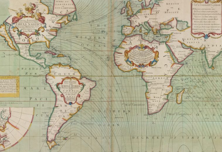
The Mercator projection was developed by Flemish cartographer Gerardus Mercator in 1569 primarily for maritime navigation. Its strength was its ability to preserve angles and directions, making it useful for sailors. It was never designed to provide an accurate comparison of the relative sizes of continents. As a result, areas become increasingly enlarged towards the poles while regions closer to the equator appear comparatively smaller.
Africa provides perhaps the clearest illustration of the problem.
The continent covers more than 30 million square kilometres, while Greenland covers roughly 2.2 million square kilometres. In reality, therefore, Africa is about 14 times larger than Greenland. Yet on a conventional Mercator world map, Greenland can appear comparable in size to Africa.
That visual discrepancy has become central to the “Correct the Map” campaign.
The Equal Earth projection offers one alternative. Created by cartographers Bojan Šavrič, Bernhard Jenny and Tom Patterson in 2018, it is designed as an equal-area projection, meaning that the relative areas of landmasses are preserved. Africa consequently appears at a scale much closer to its actual size in relation to Greenland, Europe, Asia and the Americas.
For Africa, the debate carries a significance that extends beyond cartography.
A continent that occupies approximately one-fifth of the world’s total land area can appear visually diminished on maps that exaggerate territories in the Northern Hemisphere. Such images can reinforce an incomplete understanding of Africa’s geographical scale and diversity, particularly among younger audiences encountering global geography primarily through classrooms, textbooks and digital platforms.
This is why education is likely to be one of the most important arenas for the new initiative.
If schools increasingly use equal-area maps, students will encounter a visual representation that better reflects the physical dimensions of the world. Africa will no longer appear as a relatively compact landmass beside an enormous Greenland or an oversized Europe. Instead, its geographical scale will be immediately visible.
That matters in a continent seeking to strengthen its global economic and political influence.
Africa is home to 54 countries, more than 1.4 billion people and some of the world’s most significant reserves of critical minerals, agricultural resources and renewable-energy potential. Its physical scale is only one part of its strategic importance, but representing that scale accurately can help challenge assumptions formed through generations of distorted visual information.
The UN vote also demonstrates the growing confidence of African countries in shaping global narratives rather than simply responding to them.
Togo’s leadership of the initiative, supported by the African Union, places an African country at the centre of an international debate that might initially appear technical or symbolic. Yet the campaign has connected cartography with wider questions about representation, historical memory and how institutions communicate knowledge.
Robert Dussey, Togo’s foreign minister, has argued that the issue goes beyond cartography to questions of “cognitive justice” and accurate geographic knowledge. The campaign’s supporters similarly contend that maps used in schools, newsrooms, businesses and digital platforms should provide audiences with a more faithful understanding of the world.
There is, however, an important reality to acknowledge: changing a map does not change Africa’s circumstances.
A more accurate projection will not by itself attract investment, create jobs, improve infrastructure or resolve governance challenges. Nor should the Mercator projection be treated simply as a political instrument; it was created for a specific navigational purpose and remains useful in contexts where preserving direction and angles matters.
The more constructive interpretation is that cartographic reform can form part of a broader effort to ensure that Africa is represented accurately wherever global knowledge is produced and consumed.
That process will take time. Digital mapping systems, educational materials, atlases and institutional publications cannot all be transformed immediately. The UN resolution is also non-binding, meaning implementation depends largely on governments, institutions and technology companies choosing to respond to its recommendations.
Yet the symbolism of the vote should not be dismissed.
A resolution supported by 164 countries signals broad international recognition that the visual representation of the world can be improved. More importantly, it demonstrates that African governments and institutions can place questions of representation on the global agenda and build coalitions around them.
For Africa, the opportunity is therefore larger than the map itself. Accurate cartography can contribute to a more balanced visual vocabulary through which the continent is understood, one that reflects its true geographical scale rather than inherited distortions.
The world has always been larger than the maps used to describe it. The latest UN decision offers an opportunity to ensure that the image presented to future generations comes closer to that reality.
Correcting the map will not, on its own, correct every misconception about Africa. But it is a meaningful beginning: a reminder that representation matters, that narratives can be reconsidered, and that Africa can increasingly take part in defining how the world sees it.